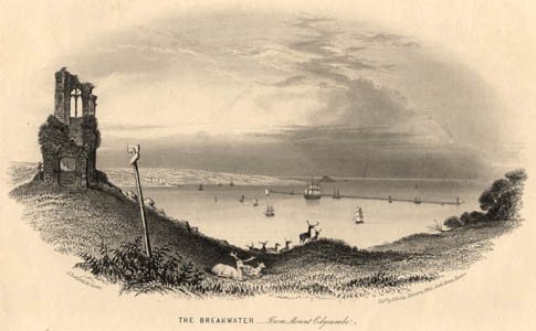
The Breakwater - from Mount Edgcumbe ([1855?])
George Townsend| Repository | Library | Shelf |
|---|---|---|
| Devon | West Country Studies | M SC2228 |
| Devon | PLY | I/S |
Illustration Reference
SC2228
Location
CD 34 DVD 5
Publication Details
Scope and Content
Jewitt, Llewellynn. The illustrated handbook of Plymouth, Devonport, and Stonehouse. Plymouth: W. H. Luke, 1865. p. 44.THE BREAKWATER, One of the finest, most stupendous, and best-constructed works of its kind in the kingdom, is situated in Plymouth Sound, in a line between Bovisand Bay on the east, and Cawsand Bay on the west. It is three miles distant from Plymouth, and forms a prominent and most interesting object from the Hoe. The Sound is about three miles wide at its entrance from the English Channel, and the frequent storms on this part of the coast rendered it next to impossible for ships to ride in safety, or even to enter and depart freely. Earl St. Vincent therefore recommended that means should be taken to promote the security of the vessels, and to make the Sound a harbour of safety. In 1806 Messrs. Rennie and Whidbey surveyed the Sound by order of the Admiralty, and recommended the formation of a detached mole or embankment on the line of shoals called the Shovel Rocks and the San Carlos Rocks. They also recommended shore projections to be prepared as circumstances might require. In 1811 the Government, after examining various plans submitted to them, determined upon adopting that of Messrs. Rennie and Whidbey, and steps were immediately taken to commence the work. [Text may be taken from a different source or edition than that listed as the source by Somers Cocks.]
Format
Steel l.engr vign
Dimensions
100x185mm
Aspects
From Mount Edgcumbe
Counties
Subjects
Dates
1855

